FastSAM DINOv2 for Mine Vegetation Restoration Assessment Using UAV Multispectral and Terrain Data
Authors
Files
Key Information
Journal

Published in Vol. 4 No. 1 (2026) of Sustainable Energy and Environmental Engineering Journal.
The Sustainable Energy and Environmental Engineering Journal (SEEEJ) eISSN 3136-8174 is a peer-reviewed, interdisciplinary, and open-access academic journal that focuses on the development, deployment, and integration of sustainable energy technologies and environmentally responsible engineering practices.
SEEEJ serves as a forum for researchers, engineers, scientists, and policy experts to present original research and innovative solutions that address the twin challenges of global energy demand and environmental degradation. The journal emphasizes scalable technologies, real-world applications, and forward-looking strategies that support carbon neutrality and long-term ecological balance.
About the JournalAbstract
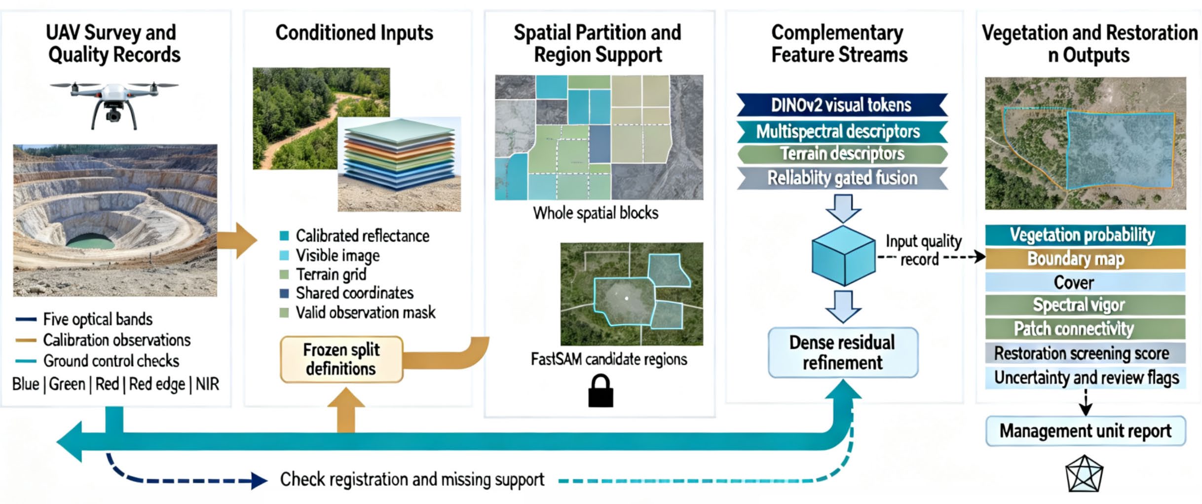
Monitoring vegetation recovery on reclaimed mine surfaces requires delineating fragmented plant cover under variable substrate, illumination, and terrain conditions. This paper presents a FastSAM DINO framework that combines candidate region generation, frozen DINOv2 appearance descriptors, and independent multispectral and terrain representations. Reliability-gated fusion integrates the three information streams, while dense refinement supports vegetation boundaries and regions omitted by candidate masks. The framework reports vegetation cover, spectral vigor, and structural patch connectivity as separate components before combining them into a restoration screening score. The reported benchmark comprises six mine domains and five spectral bands, with geographically separated evaluation protocols. Full fusion achieves a mean intersection over union of 86.4%, a boundary F1 score of 82.7%, and a mean absolute cover estimation error of 4.8 percentage points. The corresponding appearance-only values are 80.2%, 75.9%, and 7.6 percentage points. The held-mine comparison yields a mean intersection over union of 82.1%, providing a distinct assessment of geographic transfer. Confidence-based deferral relates prediction error within accepted areas to retained valid area and the associated review demand. These comparisons describe mapping performance and the behavior of the proposed screening indicators. The framework connects region segmentation and heterogeneous information fusion to spatially explicit management outputs through observation validity records, spatial partitioning, and uncertainty reporting. Wider ecological interpretation requires independent observations of restoration condition, and operational deployment requires validation of acquisition controls, indicator weights, and processing variability.