FNO GraphNet Model for Low Altitude Communication Link Prediction Using Terrain and Channel Measurement Data
Authors
Bognár Róbert, Hegedűs KárolyFiles
Key Information
Journal
Published in Vol. 6 No. 3 (2026) of Journal of Smart Operations and Management Engineering.
Journal of Smart Operations and Management Engineering (JSOME) eISSN: 3136-7666 is an international, peer-reviewed forum dedicated to publishing cutting-edge research at the intersection of process systems engineering, advanced operations research, and intelligent management. The journal bridges the gap between technical system design and executive decision-making, focusing on how data-driven algorithms, automation frameworks, and intelligent computing transform modern industrial operations.
JSOME welcomes original research articles, rigorous reviews, and methodological contributions addressing complex industrial systems, supply chain networks, energy systems, and process industries.
About the JournalAbstract
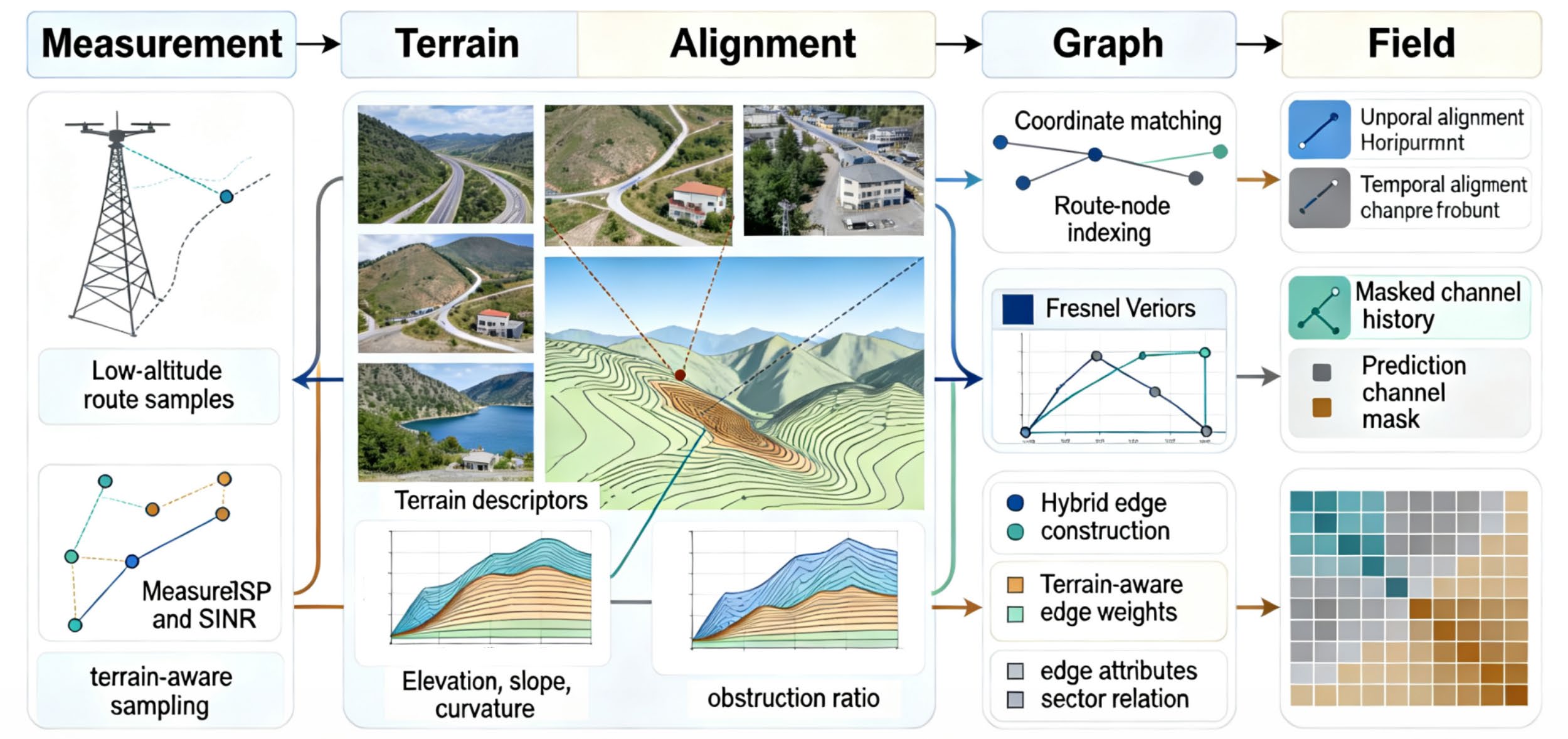
Low altitude communication links are affected by terrain blockage, near ground scattering, antenna height variation, and measurement sparsity, which make conventional empirical path loss models unstable when the aerial platform moves across urban ridges, road corridors, and river valleys. This paper develops an FNO GraphNet model for link prediction from terrain descriptors and channel measurement data. The method first maps elevation, slope, clutter category, Fresnel obstruction, and measured channel statistics onto a continuous spatial operator, and then propagates local consistency through a graph formed by neighboring flight samples and base station sectors. A Fourier neural operator captures long range terrain induced field variation, while graph message passing corrects sector dependent residuals and measurement discontinuities. Experiments were conducted on 18,420 low altitude samples collected along 42 routes with altitude from 60 m to 180 m and carrier frequency of 3.5 GHz. Compared with Kriging, random forest, XGBoost, LSTM, GraphSAGE, and a standalone FNO, the proposed model reduced received signal power RMSE to 2.41 dB and link outage F1 score reached 0.912. Ablation results showed that removing terrain spectral encoding increased RMSE by 18.3%, and removing graph propagation increased outage false alarms by 21.6%. The results indicate that operator learning and graph correction provide a practical prediction basis for low altitude route planning, adaptive base station association, and measurement efficient radio map updating. The validation design uses geographically separated route-level partitions, and the analysis links accuracy gains to outage warning, measurement-density robustness, and deployable inference cost.
Details
License
Copyright (c) 2026 Bognár Róbert, Hegedűs Károly

This work is licensed under a Creative Commons Attribution-NonCommercial-ShareAlike 4.0 International License.